The national long distance trail O4 belongs to Greece national trail network but apart from a small section over Paggaio mountain it was never implemented. The only reference to this trail may be found in a brief description provided by the Greek mountaineering federation:
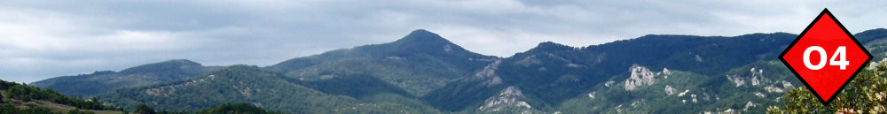
O4 connects Hortiatis mountain with Paggaio mountain and Rodopi mountains (E6 trail). It crosses Chalkidiki peninsula, ancient Amfipoli, Paggaio mountain and concludes in Toxotes by Nestos river. Only the sections from Avli to Nikisiani and from Amfipoli to Paggaio are currently signposted.
I could not also find a route of the trail (on paper) something that was already available for European trails such as E4 or E6. In 2012 I decided to make my own routing starting from Thessaloniki and ending in Amfipolis but respecting the original planning above. It took more than one year to survey and map a proposed route. In May 2014 a couple of Dutch trekkers walked the trail continuing to Kavala. After their positive feedback I decided to continue the effort to make this trail more established. I have recently rerouted some sections and properly mapped and documented the walks in English so that anybody can walk it easily with the help of GPS device since there is no signposting and no maps for most of the area. The section from Amfipoli eastwards is approximately mapped but a survey is still underway.
Trail Highlights
There are certainly much more scenic long distance trails in Greece (such as O3 through northern Pindus). You may choose to walk O4 for the following reasons.
-
Hiking is possible year around since the trail remains below 1000m (the average winter snow line) for the most of its length. Paggaio mountain (1700m) may be also bypassed from the south. Best time though is May-June and October.
-
In terms of difficulty it ranges from easy to moderate. It is also easier to break each walk into smaller segments or link them into longer ones since there are more populated places in between.
-
Although touristic facilities are not abundant there are sufficient and with the help of local transportation it is possible to organize in a hostel-to-hostel fashion (although this would require some serious organization overhead). The only places where camping is necessary is on Kerdilia mountains and on Paggaio mountain. These sections have a low trail alternative.
- The route is mostly through forests with plenty of waters, passing by several mountain villages with hospitable people.