- Distance: 15.1 km
- Duration:
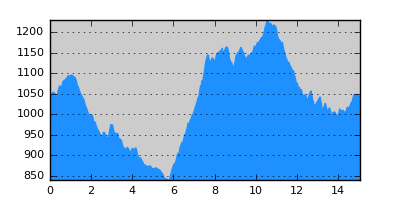
- Elevation Profile: show
Overview
A great hike in a unique landscape. Follows the valley of Paliomagero stream and then climbs to a pass above Dilofo. A good trail from there will bring you to Pentalofos village.
Description
Take the paved road climbing north out of Dotsiko to reach a saddle and the main road coming from Eptahori. On the other side of the saddle continue on a track and after 100m turn right on a wide footpath downhill along a ridge in the forest. The path is in disuse but clear and easy to follow. Reaching the bottom of the ravine, follow the riverbank downstream until you join a forest track. Stay on this track for the next 5km crossing the stream several times (there is little water in the summer but early in the season crossing may be more challenging) at the end climbing away from it. Approaching the confluence with another stream from the north the track bends right downhill. Continue straight on a footpath to reach the chapel of Agios Minas where centuries ago the village of Mageri was (now Dasilio up on the hill).
Now cross the tributary stream and start climbing the obvious ridge ahead. You should soon be on the footpath to Dilofo. The path is nowadays in disuse and at places buried under tall grass but as soon as you stay close to the ridge, ignoring a couple of side trails, you should have no problem following it. While climbing enjoy the nice views of the ravine as well as the unique geology of the region. After a steep rocky section the path becomes clear and more level and emerges on a saddle on the ridge by Profitis Ilias chapel (there is a covered porch) with great views. A track from Dilofo also ends up here.
There are several alternatives from this point. A small path on the other side of the saddle depicted on the map (sparsely signed and a bit overgrown at places but generally easy to follow) descends to Dilofo village in half an hour. There are no amenities there but if you have time it is a worthwhile visit to enjoy the unique traditional architecture. You can climb back on the ridge along the depicted forest track. Otherwise to continue to Pentalofos you have to continue on the ridge bypassing the rocky peek ahead either from the west along goat trails (very sparse signposting) or from the east along the forest track . The first alternative is a bit shorter but the path is steep, fuzzy and seriously eroded at places. Either way you end up on another saddle. Leave the track coming here and follow the ridge on a narrow but distinct animal trail signed with wooden poles. Continue climbing almost to the top of Splina peek with superb views and then climb down again to a saddle and shrine. Leave the ridge path and veer right downhill. There is considerable undergrowth that makes the path hard to follow at places, but soon after climbing down over some rock slabs the path goes into the chestnut forest where it is wide and clear again. Eventually you will emerge at a clearing where Agia Sotira chapel is located. A paved path continues down to a track and fountain.
Turn left on the track but after 100m turn right again on the footpath gently down to a gully crossed over a stone bridge (actually newly constructed where the old bridge stood). Then the path, paved from here on, traverses a steep rock face to emerge at the south of Pentalofos village. Follow the signs (red - yellow marks) through the village to finish the hike in the central square.
Amenities
There is a hostel, few tavernas and shop in Pentalofos.
Signposting
The section from Pentalofos to Dilofo is signposted although not very consistently.
Transportation
Taxi to Neapoli and then bus to Kozani.
Maps
Anavasi map "Gramos, Smolikas, Voio, Vasilitsa" (1:50000)
