
- Distance: 17.0 km
- Duration:
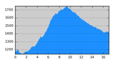
- Elevation Profile: show
Overview
A moderate climb through pine forests will bring you to Salatoura pass at 1700m. Then the route descends gently to the heart of the majestic Valia Kalda valley. The route is generously shaded and with plenty of water.
Description
From Milia, first follow the road down to the valley and then turn right along the national road to Grevena past a few houses. After 200m turn left on a track with a sign just after a few meters (P7, blue square in yellow background). Continue on this track soon with a large stream on your left hand. After a while the track begins to climb with consecutive switchbacks. The path instead continues straight uphill crossing the track several times. Eventually on a junction you turn left on a rough track approaching the river. After 700m you have to be careful to leave this track and turn right on a faint path. There is an E6 sign on the trunk of a tree a few meters above the track. Soon the traces of the old path become more clear but in any case look for the signposts which are not dense but helpful anyway. The path approaches a stream where a forestry track joins from the left. Cross the stream and continue on this track steeply at places now through mixed beech and pine forest. Eventually join a wide track and turn left along it. Continue on the road past a landslide out of the forest to reach Salatoura pass.
This is a junction of several forest tracks. Continue on the track that descends to the other side of the pass. The rest of the route is on this track that descends with several switchbacks to the bottom of the valley. Alternatively at the first right turn of the track you may turn left and follow the broad valley to the west to reach the main ridge (P7 signposting). Follow the ridge to Flega peak, the alpine lakes and then take the good signed path down to Arkoudorema (at least 3 hours from the pass).
Amenities
You have to camp in the wild at the heart of the park (there is water nearby). Although camping is officially prohibited, in practice it is tolerated as soon as you follow minimal impact practices.
Signposting
There is a local path-system signposting (P7 path: Milia -Flega) that is blue-yellow squares. There are also E6 signs and some red paint splashes. The signposting is not very dense and thus care is needed at places.
Transportation
None.
Notes
The route contains high altitude sections that maybe under snow from late October to early May.
Maps
Anavasi map "Valia Kalda - Vasilitsa" (1:50000)