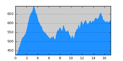
- Distance: 17.1 km
- Duration:
- Elevation Profile: show
Overview
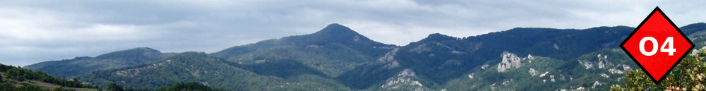
An adventurous hike across the Havrias river valley.
Description
The direct line between Arnea and Megali Panagia is interrupted by the deep gorge of Havrias river. The old route passed the river on the north close to the current paved road. Saying that, it will take you less than 3 hours to reach Megali Panagia following the main road. The proposed route is a patchwork of roads and trails that try to avoid the road making it much more interesting but also longer. The route is almost exclusively through forests and the crossing of Havrias ravine is very beautifull. Nevertheless, on the second half of the route the trail system is in disuse and there are several orientation difficulties which will make it impossible to follow it without a GPS track. Also the cumulative ascent is more than 600m.
Starting from the central square of Arnea, take Filippou street out of the village and continue on a paved track south-east. Where the paved road turns right, stay left now a dirt road soon coming to a saddle. Continue on the other side of the saddle, downhill, along the eastern slope of a beautiful ravine. It should be about 4km after the saddle when you have to leave this track and turn left on a smaller track ascending gently. It is possible to continue on the original track following an old water pipe and join the route again by the river. However this track has become a bit overgrown later on. If you have time you may also visit the ruins of the Neposi Byzantine castle (see map) which involves crossing of the river (not difficult in summer). Back on the main route, the small track continues north and fades out before a large meadow. Continue north on a faint path across the meadow to the top of the ridge to find the footpath (not easy). The footpath is in disuse but nevertheless in good state. It descends to a gully where the path has been destroyed for a few meters by debris from a road ending a few meters above, Find the path on the other side of the gully and continue through beautiful forest. Soon after you pass a third gully there is a tricky junction where you have to bear right on a smaller path which will bring you down to the river. In the summer months or early autumn a dry crossing of the river is possible here (jumping from rock to rock) and you continue on a rough track on the opposite side. Otherwise walk to the left along but 50m further from the river on a very indistinct path to reach the secluded chapel of Kimisi Theotokou, and pass the river over a footbridge joining the same track mentioned before. Turn left now along this track to join the paved road to Megali Panagia.
Cross the road and continue on a dirt road on its other side. The road ends before an old farm. Cross a small stream to find the path that climbs ahead on a ridge through oak forest. It is narrow and fuzzy at places. Subsequently it passes from a clearing where it disappears but keeping close to the stream on your right you will find it again as it crosses the stream and starts to climb more steeply along a ridge. It is very indistinct now but as soon as you keep on the ridge there is should be no problem. Finally, close to the top of the ridge, it is blocked but you easily escape to the left joining a forest track. Turn right along it to join a larger tracker and eventually emerge on the huge paved road leading to the gold mines of Skouries.
Turn right descending along the road with very nice views. After 500m turn left on a dirt road across fields towards the outskirts of the village visible ahead. Almost 200m after walking by a patch of pine forest, turn left on a small path (bike downhill trail) through the forest to end beside the school. Continue to the main square.
Amenities
There is a hostel and several tavernas. Also shops and pharmacy.
Signposting
None.
Transportation
There is a relatively frequent daily bus service to Arnea (Tel: 23720 22278), from where you can take the bus to Thessaloniki (www.ktel-chalkidikis.gr).
Notes
There are orientation difficulties and thus use of GPS is highly recommended.