- Distance: 15.0 km
- Duration:
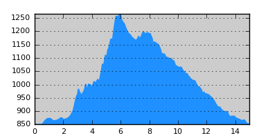
- Elevation Profile: show
Overview
Through forest, over a saddle to the ruins of Sfika village. Then along a secluded ravine to Vatohori.
Description
Walk on the main road towards Florina to Oxia village. Turn right and follow a track out of the village. After the track bends steeply right keep on along a footpath to join the road again. Turn left and walk for about 800m to another right turn. The official routing of the trail is along the road but I propose to follow the old footpath which although in disuse is easy to follow and also much shorter. So, stay left on a small grassy track descending gently. After about 600m you come to a clearing on a ridge. Turn right and follow a footpath that look like a ditch ascending through beech forest. Join the track again and walk left for 10m along it, then turn right on the footpath. After a few switchbacks the path comes to a clearing on a steep sandy ridge. Follow the ridge uphill for 100m to enter the forest again. Continue along the path which is fuzzy at places due to fallen branches and a thick layer of leaves. Eventually after a steep left turn the path becomes very clear and starts to traverse the slope more gently. There is only one difficult point by a gully where the path has becomes overgrown and disappears for a while but after that it is fine again emerging on a saddle where the road joins too.
Now either follow the road on the other side of the saddle or continue straight ahead on the footpath. Both descend to a magnificent valley where once Sfika village was located. The village was abandoned after the civil war and now only a few walls stand. Continue on the track downhill and after a shrine, turn right on a junction and continue south-west, crossing a small stream. The track now continues in the shade of the forest along a deep ravine and leads to a pen (E6 sign) in a magnificent location with amazing views of Triklario peak on the west. There is a trough here with potable water. Cross the stream and immediately turn left along a grassy path that finishes by the stream. Now continue along the streambed through dense forest. During the summer and autumn the stream dries up but earlier there is some water flowing. There are also a few fallen trees along the way but generally the going is easy. Pass a clearing where a forest track ends and continue along the streambed to eventually join a rough track. As you walk on the track becomes better and better keeping higher from the valley but it eventually descends to the valley again. At a junction stay left (right goes to Vatohori village) and follow the valley until you join the national road from Kastoria to the Albanian border and Kristalopigi.
Amenities
There is nothing in Vatohori, so head on.
Signposting
There are only a few signs on the second part of the route. Also some plastic ribbons.
Transportation
There are some private bus lines coming from Thessaloniki and Athens and going to Tirana through Kristalopigi.
Maps
Anavasi map "Prespa - Vitsi - Voras" (1:50000)
