
- Distance: 28.4 km
- Duration:
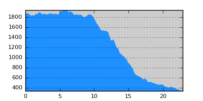
- Elevation Profile: show
Overview
A magnificent traverse of the alpine pastures of Kaimaktsalan followed by a beautiful descent through beech forest all the way to Orma.
Description
The "official" route should be the dirt road starting from Damaskinies saddle and descending along Aspropotamos valley to join the newly constructed paved road to the ski center coming from Orma. A much better alternative is described here.
Take the track behind the cow stall at Tourkolivado, soon becoming a well trodden path. Cross the Kremasi stream over a bridge and continue traversing grassy slopes to reach another stream. After crossing it take the right branch at a junction soon starting to descend gently. Cross several springs, streams and shepherd hut ruins to finally reach a hut and pen after about 3 hours from the start.
Take the track a few meters below the hut (it is possible to avoid the track by following an ill defined footpath) to a saddle at Dokari. Now leave the track and continue east on the ridge ahead. After 800m you should notice a clearing on your right hand. Bear right and cross the clearing downhill towards the forest to find the signs. Once in the forest the path is easy to follow descending with switchbacks through dense forest to finally join a dirt road by a pipe bringing water to the small power plant of Orma. Follow this road to emerge at the paved road linking Orma to Loutraki.
Amenities
Plenty of accommodation and food options in Orma and much more in Loutraki.
Signposting
There is sufficient signposting (not E6).
Transportation
There is a regular daily bus service from Loutraki to Aridaia and on weekdays from Orma to Aridaia (Tel: 23840 21249)
Notes
The route contains high altitude sections that maybe under snow from late October to early May.
Maps
Anavasi map "Prespa - Vitsi - Voras" (1:50000)