
- Distance: 17.0 km
- Duration:
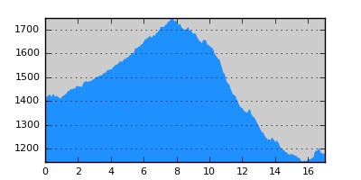
- Elevation Profile: show
Overview
The first section is a gentle climb along the majestic Valia Kalda valley to Salatoura pass at 1700m. From there descend on a combination of tracks and paths along another valley to reach Milia village. The route is generously shaded and with plenty of water.
Description
From the heart of the Valia Kalda follow the track south that ascends gently along the valley. Soon the track starts to ascend to the Salatoura pass visible ahead with consecutive switchbacks. Once on the pass, continue on the track going east on its other side (there is a misleading sign here point right). Descent genty near the edge of the forest and 200m after a water reservoir turn right along a rough track, steeply. There should be a sign 100m downhill. Continue through forest, steeply at places down to a large stream. Crossing the stream do not follow the forest track down along it, but continue straight on a faint path densely signed with red paint splashes. Eventually join a track and turn left along it to join a wider track. This descends with consecutive switchbacks. Instead, look for the signs that direct you straight on crossing the road several times. Finally join the track for the last time and follow it along the river on your right hand all the way to the outskirts of Milia village where the track joins the national road to Metsovo. Turn right and follow signs to Milia.
Amenities
There is a hostel and taverna in Milia.
Signposting
From Salatoura on, there is a local path-system signposting (P7 path: Milia -Flega) that is blue-yellow squares. There are also E6 signs and some red paint splashes. The signposting is generally adequate but some care is needed at places.
Transportation
Take a taxi to Metsovo (bus only once a week) or hitchhike.
Notes
The route contains high altitude sections that maybe under snow from late October to early May.
Maps
Anavasi map "Valia Kalda - Vasilitsa" (1:50000)