
- Distance: 16.0 km
- Duration:
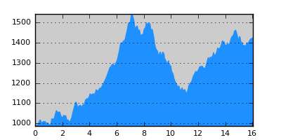
- Elevation Profile: show
Overview
The route traverses the steep western slopes of Vasilitsa mountain over wild country with superb views to reach Agia Paraskevi monastery of Samarina. Then follows the paved road to the village. It is a relatively demanding route with more than 800m ascend and the path is rough at places.
Description
From Distrato follow the main road to the ski center and Grevena for about 5km. After the fourth hairpin bend of the road, turn left on a forestry track with a sign after a few meters. Continue uphill soon on footpath, traversing the wooded steep slopes. The trail is narrow and eroded at places thus some surefootedness is needed. The signposting is also not very dense so take care not to miss the signs. Eventually the trail passes a saddle at its highest point (about 1500m) and starts its descend. From here on there are superb views of Smolikas mountain and Valia Kirna valley. Pass a spring and descend steeply to a flat thunder-striken saddle, a balcony to the Smolikas range. Continue steeply across a stream, passing over several rocky spurs. After crossing over a scree slope, the trail becomes more gentle and well defined and gradually descends to the river ahead.
You should spot the signs on the opposite side. The old wooden bridge has been washed out so find the widest point and cross to the other side and then come back to the signpost. From here on the signposting disappears (it most probably follows the dirt track a few meters above) so walk to the right on a faint path along the river, cross a dirt track and continue along a grassy gully out of the forest. Continue uphill on the smooth slopes to join the paved road before the chapel of Sotiros. Turn left on the road and walk the remaining 4km, luckily in shade, to Samarina village.
Amenities
Samarina offers several hotels and restaurants.
Signposting
There is sufficient signposting along the route (E6 signs, red-yellow squares).
Transportation
None.
Notes
The crossing of the river below Samarina may be difficult early in the season or after heavy rain, since the stream can be waist deep. In this case you may follow the river bank upstream until you find the track coming from the monastery. This crosses the river over a ford and thus more safely. Then you can rejoin the route.
Maps
Anavasi map "Gramos, Smolikas, Voio, Vasilitsa" (1:50000)