
- Distance: 16.0 km
- Duration:
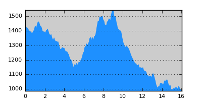
- Elevation Profile: show
Overview
The first part is an easy shaded walk, on a paved road, down to Agia Paraskevi monastery. Then the trail crosses the river and traverses the steep western slopes of Vasilitsa mountain over wild country with superb views. The trails ends on the paved road 5km above Distrato. It is a relatively demanding route since path the is rough and steep at places.
Description
From Samarina follow the road south out of the village. Continue through beech forest to reach Agia Paraskevi monastery. The signposting starts down by the river bank. To get there, follow a faint animal trail before Sotiros chapel along a wide ridge and after 200m turn left to the bottom of a shallow gully where the path becomes clear. Continue descending, now into the forest, to join the track from the monastery. Continue on the opposite side of the track following a very faint trail diagonally to the right until you come to a point where it is possible to descend to the river bank.
There is a signpost here. Walk along the bank upstream for 10m to find the widest point to safely cross the stream. You should then find signs on the opposite bank. Now the path starts to ascend, steeply at the beginning, more gently later on to pass a rocky spur high above the river. It continues uphill traversing wooded steep slopes and more rocky spurs and scree. The trail is narrow and eroded at places thus some surefootedness is needed. The signposting is also not very dense so take care not to miss the signs. After crossing a stream the trails climbs steeply to the top of a flat thunder-striken saddle, a natural balcony to the Smolikas range and Valia Kirna valley. Continue steeply along the ridge to find the signs again. Continue traversing uphill but more gently, past a spring, to reach a saddle, the highest point of the route (about 1500m). Now the trail starts its descent, still rough and eroded, and eventually becomes wide (a forestry track) and joins the paved road coming from the ski center. Turn right and follow the road, not pleasantly, but with nice views to complete the hike after 5km in Distrato.
Amenities
Distrato has a hostel and taverna.
Signposting
There is sufficient signposting along the route (E6 signs, red-yellow squares).
Transportation
None.
Notes
The crossing of the river below Samarina may be difficult early in the season or after heavy rain, since the stream can be waist deep. In this case you may instead follow the dirt track coming from the monastery which crosses the river over a ford and thus more safely. Then you can rejoin the route by walking along the bank downstream.
Maps
Anavasi map "Gramos, Smolikas, Voio, Vasilitsa" (1:50000)