
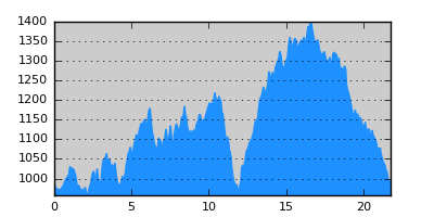
- Distance: 21.8 km
- Duration:
- Elevation Profile: show
Overview
A beautiful traverse of the eastern flanks of the thickly forested Aoos valley. It is not an easy hike since the path crosses two deep ravines before descending to Distrato. Parts of the trail have become overgrown adding to orientation difficulties despite the good signposting. Yet the route is still fairly walkable and certainly worth it.
Description
Take the paved road out of Vovousa towards Perivoli. After about 1km turn left on a dirt road. There is a red-yellow square on tree after a few meters and plenty afterwards. Continue gently uphill parallel to the river through pine forest. After about 2.5km where the road bends east away from the river there are several signs pointing left along the old footpath. The path descends gently now through beech forest, initially a bit overgrown but generally easy to follow. Come to a stream and cross to the other side. Now the trail climbs through fir and is indistinct due to forestry works yet sufficiently signed. Soon after join a forestry track and follow it to the right, through considerable undergrowth ignoring a couple of signs (blocked section). Join a dirt road and turn left along it to come to a clearing on the a ridge (Paliomonastiro area).
Continue on the road for another 5km, pleasantly and with nice glimpses of Aoos ravine. There are a couple of junctions along the way but they are correctly signposted. Eventually the road comes opposite of the seer rocky slopes above Stathis ravine and bends north-west descending. At a signed junction leave the road and turn left along a narrow footpath. The path descends gently at the beginning and more steeply afterwards with several switchbacks to negotiate the steep slope. Approaching the stream, the path traverses a rocky spur with breathtaking near vertical drops, finishing at the stream bank, after 300m altitude lose. Signs of brown bear activity are evident in the area.
Crossing the stream head straight up in thick vegetation until you spot the next sign. Continue on the footpath that from here on is quite fuzzy, approaching another stream. The path continues along this stream crossing it a couple of times. After that the path disappears under tall grass for about 200m. Continue along the stream past the ruins of a building where the path becomes clear again and descend to the stream crossing it one more time. It now ascends on the left side of a small dry stream. But after 200m it turns left and climbs more steeply away from it. The turn is indicated by yellow paint on a tree which is easy to miss. From here on the path is practically lost, and you have to rely on your imagination and the not so dense signposting to find your way. Eventually the trail joins a forestry track at a hairpin bend which you follow to the left (uphill) through plenty of undergrowth. After the next sharp turn of the track there are more signs. Unfortunately this section of the trail has become nowadays very difficult to follow (it crosses a slope that was burned in the past). Instead continue on the track to join the forest road high on the ridge and turn left along it eventually turning to each north side. Magnificent views of Aoos gorge open up with splendid views of Smolikas and Timfi range. Descent towards Distrato, visible ahead, continuing on the road for about 5km.
Amenities
A few hostels and taverna.
Signposting
There is sufficient signposting along the route (E6 signs, red-yellow squares, red disks and yellow blazes). Still care is needed at places.
Transportation
There is an infrequent bus service towards Konitsa.
Maps
Anavasi map "Valia Kalda - Vasilitsa" (1:50000)
Though the route is depicted incorrectly.