
- Distance: 14.1 km
- Duration:
- Elevation Profile: show
Overview
A beautiful hike along a historic trail.
Description
The route follows the old covered water supply pipe used for hydration of Kavala during the Turkish occupation. The path was recently waymarked while information boards with various historical notes have been placed along the second half of the route.
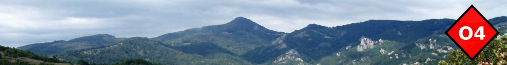
Start on the southern edge of Palia Kavala opposite to a water tap by the main road and a signpost. Descent on a dirt track towards the stream ahead and on a junction turn left on a broad path soon coming by the stream. Cross it over a wooden bridge and continue gently uphill a bit steeply at first but more gently later on. Enjoy occasional views of majestic Paggaio mountain and the plane of Philipi before coming to a saddle with kiosk. In clear weather there are amazing views from here to Thassos island.
Immediately join a dirt road and turn right along it. After about 500m turn left on a signed and laid trail through sparse vegetation to come to the spring at “Mana Nerou” (mother of water). Continue steeply downhill on steps to the bottom of a ravine and continue gently along the well shaded ravine now walking on top of the stone paved water pipe. Pass a couple of impressive stone bridges to join a track below the huge valley bridge of Egnatia motorway. Follow this track and after 200m rejoin the path again passing more stone bridges and a few farm houses before entering Kavala.
Amenities
Kavala is a very beautiful and peaceful town with several things to see.
Signposting
Very good.
Transportation
Frequent service to Thessaloniki, Xanthi and beyond. You may also take the ferry for a visit of Thassos island.